Womerah Range trail
Sydney and surrounds, North Coast
Overview
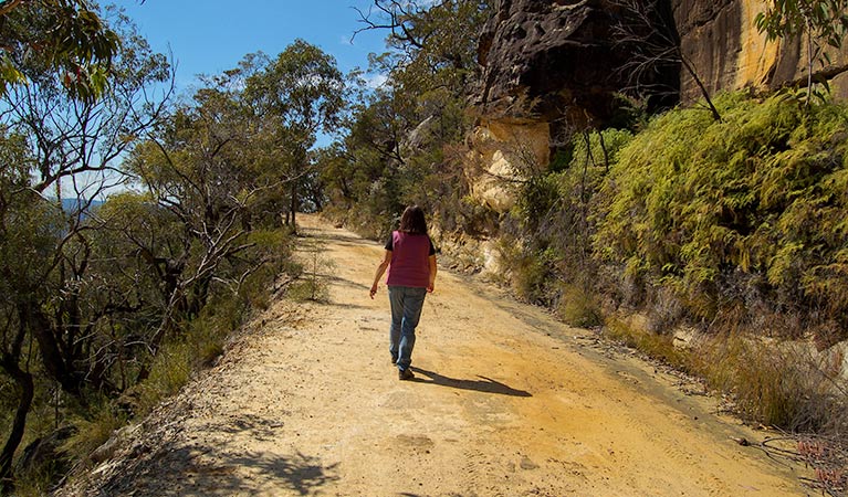
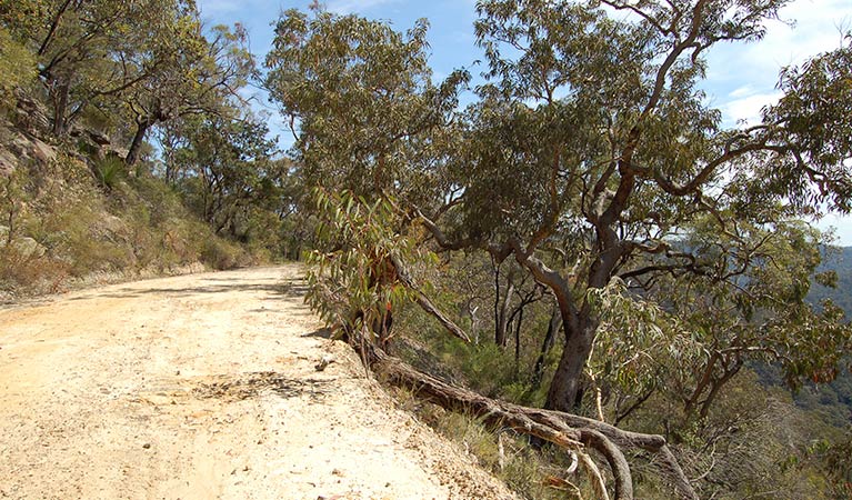
Womerah Range trail is a challenging hiking and mountain biking route with scenic views through the dramatic sandstone landscape of Parr State Conservation Area.
- Distance
- 48km one-way
- Time suggested
- 2 days
- Grade
- Hard
- What to
bring - Drinking water
- Please note
This park is in a remote location, so please ensure you’re well-prepared, bring appropriate clothing and equipment and advise a family member or friend of your travel plans.
Explore the rugged and remote landscape of Parr State Conservation Area on foot or by mountain bike along Womerah Range trail. This steep and sometimes sandy track makes for a challenging experience, especially if you’re cycling. Enjoy scenic views of cliffs, rocky outcrops and dramatic gorges from this ridgeline track though Hawkesbury sandstone country. Stop for a picnic along the way and gaze out upon McDonald Valley and nearby Yengo National Park.
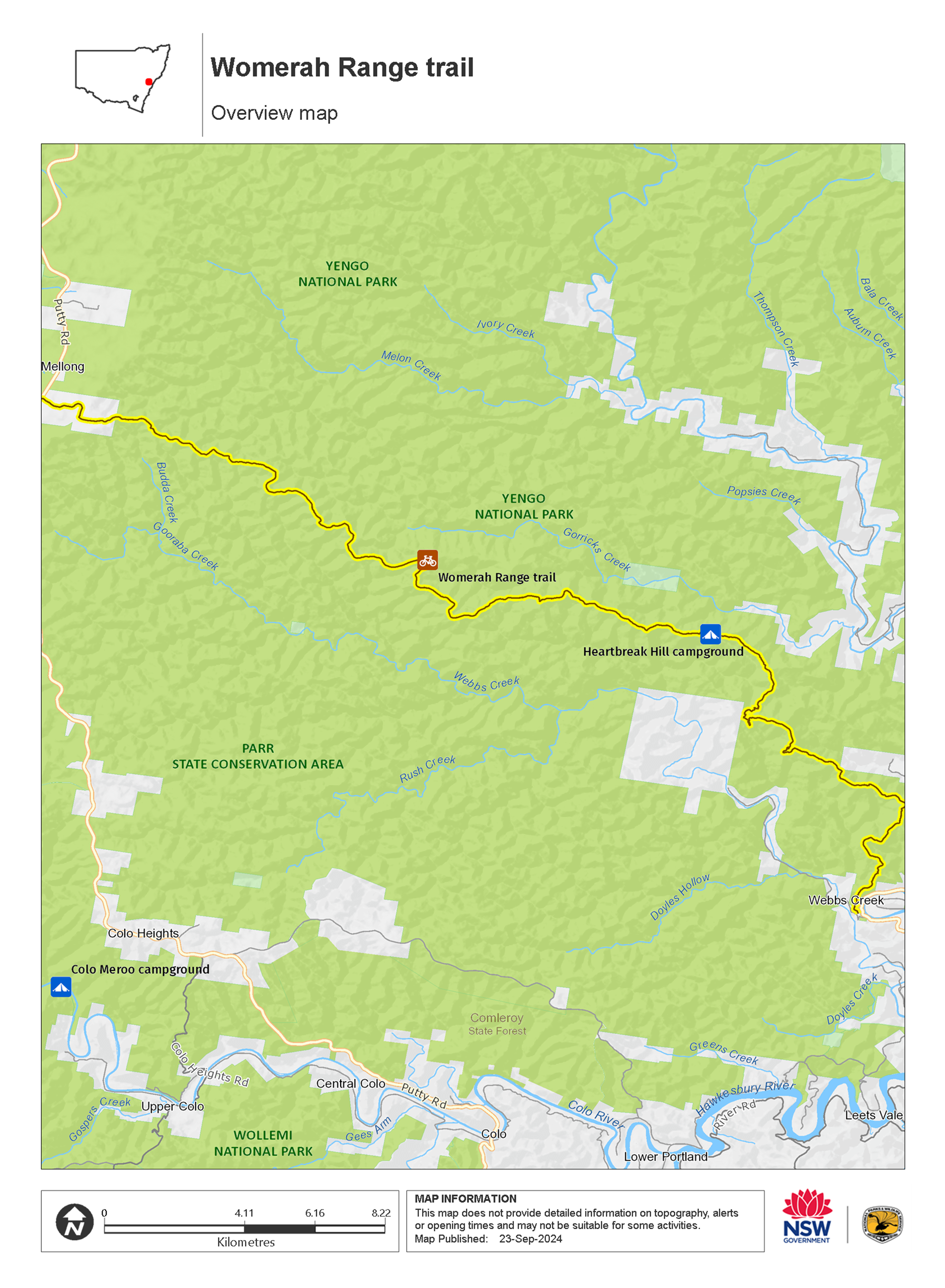
If you’re hiking and want to complete the whole track in two days, why not do a car shuffle and begin at the main entrance off Webbs Creek Road and finish at Parr’s western entrance on Putty Road? Otherwise, you could hike in from either entrance, stay overnight at Heartbreak Hill campground then retrace your steps the next day. There are plenty of possibilities.
Map
Map legend
Local alerts
For the latest updates on fires, closures and other alerts in this area, see https://uat.nswparks.cloud/things-to-do/cycling-trails/womerah-range-trail/local-alerts
General enquiries
- National Parks Contact Centre
- 7am to 7pm daily
- 1300 072 757 (13000 PARKS) for the cost of a local call within Australia excluding mobiles
- parks.info@environment.nsw.gov.au
Park info
- in Parr State Conservation Area in the Sydney and surrounds region
Parr State Conservation Area is always open but may have to close at times due to poor weather or fire danger.
- in Yengo National Park in the Sydney and surrounds and North Coast regions
Yengo National Park is always open, but may have to close at times due to poor weather or fire danger.
The Big Yango precinct of the park is within locked gates and requires a permit to enter.
Visitor info
All the practical information you need to know about Womerah Range trail.
Maps and downloads
Learn more
Womerah Range trail is in Parr State Conservation Area. Here are just some of the reasons why this park is special:
Extraordinary plants

Parr contains an unusual mix of plant species which are not only different from those growing further north in Yengo National Park, but are normally found in completely different parts of NSW. Vegetation ranges from open woodlands along the dry ridges to communities of open forest and tall open forest, heathlands, mallee and sedgelands. Flowering plants typically found in Parr include grey spider, flannel, eriostemon, and mountain devil.
- Womerah Range trail Womerah Range trail is a challenging hiking and mountain biking route with scenic views through the dramatic sandstone landscape of Parr State Conservation Area.
Convict trail
This area was named after William Parr, who was one of the earliest European explorers of overland northern routes out of Sydney. A draughtsman, boat builder and mineralogist, Parr was transported on the Fortune in 1813 at the age of 39, having been convicted of forgery. Despite a 14-year sentence, Governor Macquarie quickly made use of his skills and soon assigned him to the Surveyor General’s department as a mineral surveyor. In October 1817, Parr and his party set off from Windsor to find a trafficable route from the Hawkesbury to Hunter River, but did not quite reach Hunter Valley. Early European transport routes between Sydney and Hunter Valley are evident within Parr State Conservation Area, with remnants of Putty Road/Old Bulga Road. Today, Parr conserves Webb Creek catchment.
In the beginning

It was probably around 13,000 years ago that Aboriginal people first moved into this area. Until European settlement, these people lived off and nurtured the land and a large number of Aboriginal sites have been recorded within Parr. Mount Yengo (originally Yango), in adjoining Yengo National Park, is of particular significance; it was the place from which Biamie left the earth after creating the world, flattening the top with his foot as he went. Many sites within Parr, Yengo and the surrounding regions are closely connected with this mountain. Today, the local Aboriginal community retains a strong and active interest in the management of these sites and the landscape, along with a desire to preserve, as well as revive, Aboriginal culture.